

U.S Fire Dangers
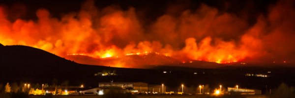
On Dec. 30, 2021, a wildfire swept through suburban neighborhoods in Boulder County destroying nearly 1,000 homes and forcing tens of thousands of residents to evacuate. The fire spread with astonishing speed prompting the evacuation of 35,000 people and burning about 6,200 acres
The wildfire, which Gov. Jared Polis called a “force of nature,” came unusually late in the year for Colorado, where a severe, multiyear drought set the stage for the fire to spread with ease. The Boulder area was hit with high winds, including gusts of nearly 110 miles per hour, fanning the flames coming two weeks after a powerful storm system generated dust clouds in Colorado and other extreme weather across the Midwest.
The fire was compared to the 2013 Black Forest fire, at the time the most destructive in Colorado’s history, destroying about half as many homes.
In California, the wildfire season experienced an unusually early start amid an ongoing drought and historically low rainfall and reservoir levels. In January 2021 alone, 297 fires burned 1,171 acres (4.74 km2) on nonfederal land according to the California Department of Forestry and Fire Protection, almost triple the number of fires and more than 20 times the acreage of the five-year average for January.
Unfortunately, these were not one-time freaks of nature.
Analyzing Wildfires
A new University of Colorado Boulder-led paper shows that large fires have not only become more common, but they are also spreading into new areas, affecting land which previously had not been in danger.
The paper’s writers analyzed data from over 28,000 fires occurring between 1984 and 2018 using the Monitoring Trends in Burn Severity (MTBS) dataset. Monitoring Trends in Burn Severity (MTBS) is an interagency program whose goal is to consistently map the burn severity and extent of large fires across all lands of the United States from 1984 to present.
MTBS examines all fires 1,000 acres or greater in the western United States and 500 acres or greater in the eastern Unites States.
Data analysis confirms fires have gotten larger, more frequent, and more widespread across the United States since 2000.
“Projected changes in climate, fuel and ignitions suggest that we’ll see more and larger fires in the future. Our analyses show that those changes are already happening,” said Virginia Iglesias, a research scientist with CU Boulder’s Earth Lab and lead author of the paper.
Analyzing the data, the report compared the 2005 – 2018 fire seasons to the preceding two decades. In both the West and the East, fire frequency doubled. In the Great Plains, fire frequency quadrupled. The amount of land burned each year increased from a median of 1,552 to 5,502 square miles in the West and from 465 to 1,295 square miles in the Great Plains.
Over the course of 20 years, the amount of land burned each year more than tripled.
Additionally, the analysis concluded that the size of fire-prone areas increased in all regions of the contiguous United States in the 2000s meaning the distance is smaller between individual fires and that fires are spreading into areas which had not burned in the preceding time periods.
These results confirm what had been suspected by the media, public and fire-fighting officials: fires are getting bigger, affecting more populated areas and are harder to fight. These results align with other troubling risk trends: “These convergent trends, more large fires plus intensifying development, mean that the worst fire disasters are still to come,” said William Travis, co-author, and Earth Lab deputy director.
In other words, with more development, and spreading populations, more homes, people, and towns are at risk of fire.
The Camp Fire of 2018 in Northern California is one of many examples. The fire was the deadliest and most destructive wildfire in California history and the most expensive natural disaster in the world in 2018 in terms of insured losses.
Drought was a factor: Paradise, in the Sierra foothills, which typically sees five inches of autumn rain by November 12, had only received one-seventh of an inch by that date in 2018.
The fire, ignited by a faulty electric transmission line, caused 85 civilian fatalities, injuring 12 civilians and five firefighters. It covered an area of 153,336 acres (239.6 sq mi), and destroyed more than 18,000 structures, with most of the destruction occurring within the first four hours. The towns of Paradise and Concow were almost completely destroyed, each losing about 95% of their structures.
Aspen Insurance Agency is a family-run business in Denver, Colorado servicing clients nationwide. We work with multiple insurance carriers to offer our customers a wide variety of risk reduction coverage at the lowest possible cost. We offer a wide range of personal, auto insurance, commercial and professional insurance to residential and commercial insurance customers enabling the cheapest rates available. Call to speak to one of our professionals for home or business insurance and see how painless insurance shopping can be.